The park is bordered by Market to the north, Leffingwell to the east, Magazine to the south and Glasgow to the west.
The park takes its name from James E. Yeatman (1818-1902):
Yeatman, who arrived in St. Louis from Tennessee in 1842, established a local branch of the Nashville Iron House. In 1846 he was among the founders of the Mercantile Library Association and in 1850 he entered the commission business. Ten years later, Yeatman became president of the Merchants Bank and during the Civil War he headed the Western Sanitary Commission, an agency set up to care for wounded Union Army soldiers. After the war, he continued as head of the bank, which later became the Merchants-Laclede National Bank. Yeatman was well-known among St. Louisans as a philanthropist and civic leader. He resided on East Grand Avenue near Bellefontaine Road.
An idea of the appearance of the Yeatman area in his day can be obtained from Compton and Dry's pictorial atlas of St. Louis, published in 1875. This work, by a series of birdseye views, shows this neighborhood to have been well built up in its eastern and southern sections with homes of the well to-do and upper middle class. A few mansions were interspersed among smaller detached single family dwellings in the area south of Easton Avenue. North of that, row houses became prevalent in a neighborhood that was about 75 percent built up.
North of Cass Avenue and west of Jefferson, as far north as North Market Street, were largely vacant areas with some industry evident. Beyond North Market Street to St. Louis Avenue and west toward Glasgow was a compact area of small detached dwellings in the Penrose Tract. On present day Madison Street, east of Glasgow Avenue, was the Penrose Public School, while north of Madison and west of Glasgow, as far as Garrison, was a large quarry.
A horse car line ran out Cass Avenue with a branch running north on Glasgow and thence west on St. Louis Avenue. Fronting on Montgomery Street, east of Grand, was the large Mullanphy Hospital in a section of open land pocked with sink holes and relatively underdeveloped.
At this time, the land north of Morgan Street (now Delmar) and west of Compton was largely vacant up to Grand Avenue. Some large houses were located on the east side of Grand, as far north as Franklin Avenue, northward from there were open fields as far as St. Alphonsus Catholic Church, north of which was the John N. Booth estate at the southeast corner of Grand and Page. Beyond that were a few blocks of houses as far as the horticultural establishment of J. M. Jordan near North Market Street.
A few prominent landmarks in the Yeatman area in 1875 were the Veranda Garden road house at the Easton-Franklin wedge; the large house of General William T. Sherman on Garrison north of Franklin Avenue; Divoll Public School on Dayton Street; the American Wine Company at Cass and Garrison and St. Mark's English Lutheran Church on Elliott Avenue at present day Cole Street.
Outstanding residences were the Glasgow Homestead at Garrison and Sheridan Avenues, the mansard style mansion of L. M. Rumsey at Beaumont and Morgan Streets and Governor B. Gratz Brown's house on Webster near Sheridan.
The earliest public park was Gamble Park on Dayton and Gamble Streets, east of Garrison Avenue. This 1.15 acre open space was acquired from the City Water Department in 1874. Yeatman Square covering 3.46 acres on the block bounded by Glasgow, North Market, Magazine and Leffingwell, was purchased by the City in 1906 for $40,000. During the 1950's, Jordan W. Chambers Park at Compton, Franklin and School Street; and Garrison-Branter-Webster Park, bounded by streets of those names, were developed. (source)Curiously enough, Garrison-Branter-Webster Park is not listed on the city website, although it certainly does exist.
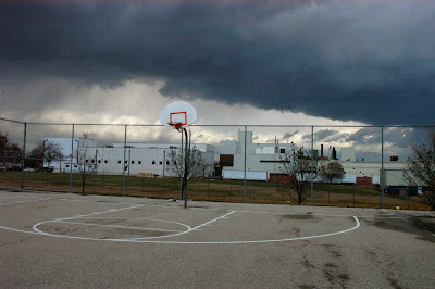
The park has basketball courts and tennis courts. The basketball courts are in playable condition although there are spray painted messages all over. Some more perplexing than others.
"No Days Off"
The tennis courts are among the best I've seen in the entire city as far as condition of surface, nets and fencing. You won't see close up photos, as the entry ways were locked. This leads me to believe the courts are used by an organized group or school and they are seeking to protect the condition from the public. A strange concept for a public park, but if you know JeffVanderLou, than you know there are not a lot of tennis matches on the schedules of the local residents.
Other than that, nothing much to see here folks.
The residential properties surrounding the park are in various states of neglect and disrepair.
There is a large warehouse to the north and several former factories/warehouses in the area as well.
The area, as seen in the bird's eye view image above has largely been decimated of its housing stock.


No comments:
Post a Comment