One of the questions I've been asked over the years is who named and plotted out the 79 neighborhoods of St. Louis.
Through a recent Twitter conversation with someone trying to understand how old the name of their neighborhood is, the topic is once again top of mind.
You know, it would be kind of cool to have a born on date for neighborhoods in the current vernacular.
"Fox Park, Established 1885" something like that...you catch my drift?
Well, I can't seem to keep my curiosity at bay for long, so I guess it's high time to dig into this one and try to get some answers.
Here are some of the questions that have been posed that I don't have answers for and hope to unearth:
What year did this map of 79 neighborhoods go into effect?
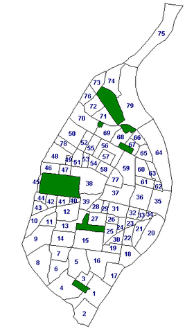
Well, the colloquial yarn is that it was put in place during the Schoemehl era. Vincent Schoemehl was mayor for three consecutive terms from 1981 to 1993.
So the early 1980's is a likely starting point to hit the records and newspapers.
When the neighborhoods were mapped out, did they stay within Ward boundaries at the time?
This is a good question, as I find it ultimately frustrating when neighborhoods have multiple alderpersons.
When were the names of neighborhoods changed?
The one most people are familiar with is McRee Town being changed to Botanical Heights. But there are others, like Cabanne becoming the West End.
If you've followed my writing on the subject, you will notice I choose to stick with the modern, accurate nomenclature and boundaries as defined by the city itself. I don't use historic terms for neighborhoods, streets, etc.
I refuse to call I-64 "Route 40", I refuse to call Martin Luther King "Easton Avenue", I refuse to call Botanical Heights "McRee Town". I love the history there, and name change controversies are not lost on me. But, being a St. Louis nerd by choice and scientist by nature, it's good to know history, but it seems intellectually dishonest to dismiss the official modern names and go with the one that suits your political agenda or ideals. Accuracy at publishing is something I strive for.
This is not always easy to do. I still catch myself calling the Scottrade Center the Savvis Center and the Bernard F. Dickman bridge the PSB...alas, none of this means much in the big picture...people will do what they want and populism and folk language is quirky and charming.
Don't even get me started on pronunciations...
But names of our neighborhoods have certainly changed over the years. My goal is not to track down when the various parts of the city were incorporated or became residential vs. agricultural vs. European settlements vs. Native American land.
I don't have that kind of time, so my goal will be to track down the story of the modern map. There are plenty of mysteries to solve in that small part of history to keep me busy.
The good news is, one of the best research librarians in town is on the case. In fact, she forwarded a St. Louis Post-Dispatch map from 1989 and this will be the start of my research. The other good news is, other curious souls are on the case as well. Hopefully we can collaborate on a decent story to share.
The good news is, one of the best research librarians in town is on the case. In fact, she forwarded a St. Louis Post-Dispatch map from 1989 and this will be the start of my research. The other good news is, other curious souls are on the case as well. Hopefully we can collaborate on a decent story to share.
If you are reading this and have done your own research, or know the story first hand, please feel free to contact me. I'd love to hear from you.
stlouiscitytalk@gmail.com
Here's the St. Louis Post-Dispatch map from 1989:

Notice there are only 74 neighborhoods?
How'd we get to 79 in current times?
Walnut Park West was carved out of Walnut Park and Mark Twain, Gravois Park and Benton Park West were carved out of Dutchtown North, Kingsway East and West were carved out of Academy/Sherman and Cote Brilliant, Covenant Blu/Grand Center was part of Jeff Vanderlou, Hamilton Heights was part of Cabanne and Near North Riverfront used to be simply North Riverfront.
If you're following me, you've probably noticed some name and number changes as well:
1. Princeton Heights was called Kingshighway South
2. Southwest is now called Southwest Garden
3. Dutchtown South is now simply Dutchtown
4. Dutchtown North is now Benton Park West & Gravois Park
5. McKinley/Fox is now called McKinley Heights
6. North I-44 is now called Botanical Heights
7. Terry Park is now part of the Gate District
8. Lafayette Towne is now the Gate District
9. Central Business District is now called Downtown
10. St. Louis University Area is now called Kings Oak
11. Cabanne is now the West End
12. Academy/Sherman is now Academy and Kingsway West
13. Cote Brilliant is largely Kingsway East
Also, the borders of the neighborhoods have changed over time. For instance, the Hill has gained area on it's northern border pushing all the way to Manchester Avenue in current times.
I hope to check in periodically and update posts to keep you informed as I learn more, kind reader.
Now I just need to carve out some time to hit the St. Louis Room and microfiche at the Central Library.
More to come...
Oh, then you'll love this about the "Bernard F. Dickman" bridge! http://www.stltoday.com/news/poplar-street-span-becomes-william-l-clay-sr-bridge/article_b79981a0-f588-5323-aa0b-3ffc034c3a45.html
ReplyDelete